
How to Study Maps for UPSC
The UPSC Preliminary Exam typically consists of four to five map questions each year. You don’t need any further convincing reasons to prepare map-based questions for the UPSC Civil Services Exam. In addition, using Maps to provide context for your answers is a foolproof strategy for increasing your score in the UPSC Mains exam. In addition to questions directly related to maps, the UPSC exam also includes several questions that can only be answered with a thorough understanding of geographical locations, i.e. through maps.
Aspirants for the Union Public Service Commission Examination often express frustration with memorizing many places, boundaries, Rivers, and Mountains on maps. When it comes to learning about maps for UPSC, most students lack the proper technique and strategy to studying them. You can join a UPSC Coaching to learn how to prepare maps under the guidance of experts.
What To Study And How To Study The Maps
Firstly, we need to divide the study into 2 Major Categories:
1. National (India)
2. International
1. National (Indian)
a. Lines
Examine the significant degrees of latitude and longitude on a map of India. For example, you need to learn about the states covered by the Tropic of Cancer across India. The Indian Standard Meridian, the longitude of Indian Standard Time, crosses across a number of states; thus it’s important to keep track of where it is. ‘Concept-based’ lines, the characteristics of coasts, etc., must also be studied. For instance, the division of India uses the 10 degrees Celsius isotherm.
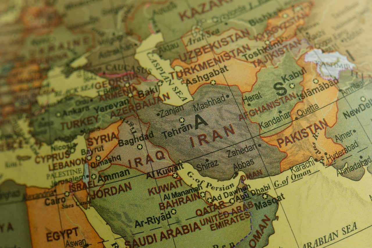
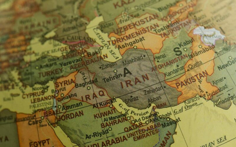
b. Neighboring Countries
Find out more about the countries that share borders with India. Take note of the many Indian states that are bordered by these nations. Give the countries of the Indian Subcontinent a higher priority. Study the water bodies around the Indian peninsula and the islands in the Indian Ocean by studying a detailed map of the area. For Example, a map of the Andaman and Nicobar Islands, a List of Countries near the Lakshadweep Islands, etc. can be studied.
c. States
It is expected that you would be able to sketch a basic outline of India’s political map (Very important for Mains Paper GS I and GS II). Find out how many states there are and which ones share boundaries with each other. Learn to recognize and memorize the location of India’s major cities. You should know where to point and which city lies to the west, east, north, and south of any given city.
Take note of the major cities that have recently been in the spotlight. For Example, a place that gained international attention due to the misuse of a pesticide was Kasargod in Kerala became an important place to remember for map questions. The eastern, western, northern, and southern boundaries of the states and UTs should be easily recognizable to you. State boundaries in India must be updated whenever a new state is created out of the current area.
d. Rivers, Lakes, and Mountains
An aspirant should study the beginnings, sources, flow paths, and tributaries of all the major rivers in India. This is necessary for answering the River Teesta question on the Prelims exam. It may be asked in the exam that, Find the major rivers’ left and right bank tributaries. For each major river drainage basin, you should be able to sketch a rough diagram on a sheet of paper.
Lakes should be easily identifiable on a political map, and you should know which states contain or originate a given lake. Many lakes also share common characteristics. Identify similar lakes and put them on a separate list. For Example, One of the largest freshwater lakes in Asia is Wular Lake, which is located in Jammu and Kashmir.
Whether Himalayan or Peninsular, be sure to jot down the total area and highest summits of each mountain range. Your ability to accurately depict the entire mountain range, including its highest peak, on a political map of India is a must. Glaciers to the north of the Vindhyas should be studied for their positions. It’s also important to take note of the many rivers that have their origins in the mountain ranges and glaciers of this region.
Engaging and Inspirational Moral Stories for Students
2. International
Learn to recognize and use the world’s major latitude and longitude lines (like the Tropic of Cancer, the Tropic of Capricorn, the Arctic Circle, and the Equator). Take note of the nations that the lines pass through. Learn which countries are on either side of the International Date Line and the Prime Meridian.
Keep track of the key physiographic features you learn about in the NCERTs and other basic geographies, history, and economics texts. You should review all of the necessary maps included in the NCERTs. For Example, If Syria, a country in West Asia, is frequently mentioned in the media, you should be able to identify its neighbors. You should also be familiar with the countries with coastlines on the Mediterranean Sea and other surrounding water bodies.
Conclusion
Learning about maps is not an additional job, and you may do it in your free time. Understanding recent news, geography, economics, etc., will be much easier with the help of a mind map of India and the world. The ability to create decent maps and locate major places/features will be highly useful, particularly in GS-1 Geography/History and GS-3 Economy.
Try looking for an outline map of India that shows only the physical features. You can use this outline map to practice drawing a map of India on a sheet of paper. Your map’s outline should have four to five sections. Then, work on each section independently. Once you’re confident that you can sketch every region of India, you can go on to draw the complete map. Starting from Jammu and Kashmir at the top of the map, and so on, working ahead from either west to east or vice versa. The same strategy can be applied to study and practice global maps.
For more in-depth preparation under experts’ guidance, you can join The Thought Tree. They provide the Best IAS coaching in Jaipur. T3 also provides free mentorship to their students. If you have any questions, then please comment down below.
This article has been sent to us by Anurag Mishra, in which he has told a very easy way to prepare the map.
How did you like this article, do tell us by commenting and you can also send your articles to us on our email badteraho@gmail.com. If you like it, we will publish your article together in your name.


0 Comments